
Cruising Falmouth and the Fal Estuary
Few harbours let you come in at any state of tide and then spend a week exploring creeks without going back to sea. How to enter the Fal, where to anchor, how far up the river a keelboat can go, and what to do ashore when it rains.
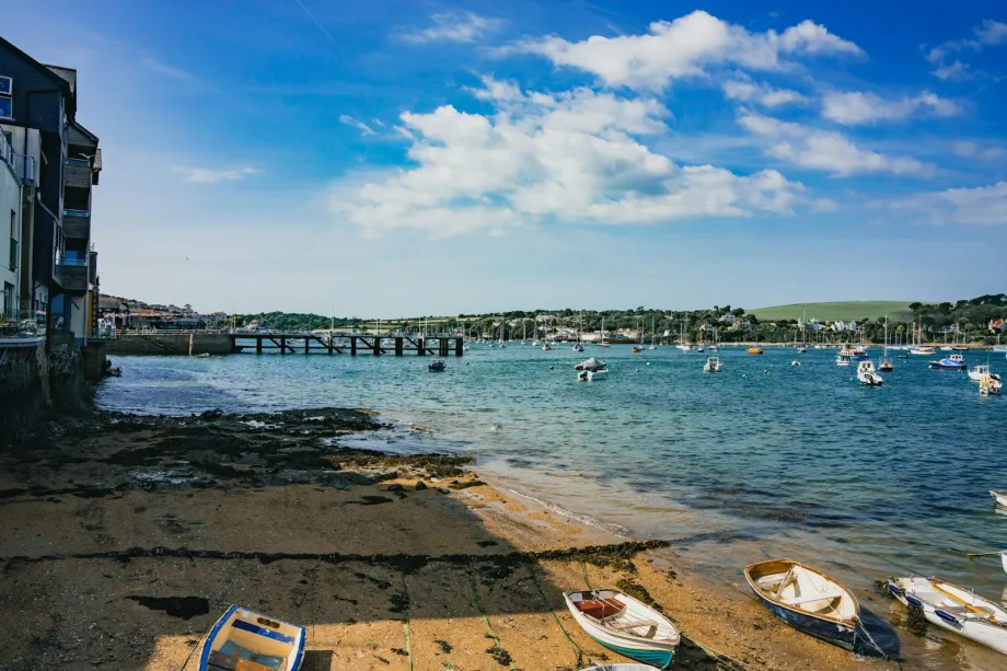
A Strategic Natural Harbour
Falmouth provides one of the finest natural anchorages on the south coast of England. Pendennis Point and the Roseland Peninsula form a wide, sheltered entrance that opens into Carrick Roads. This vast body of water offers deep shelter when Atlantic depressions roll across the Western Approaches.
For sailors heading east or west along the English Channel, the harbour serves as a major tactical hub. It gives deep-water access regardless of the state of the tide. You can arrive at three in the morning during a spring low water and still find plenty of depth in the main channel.
The port carries a rich seafaring history shaped by trade, packet ships, and naval defence. Today, it remains a working harbour where superyachts, commercial ships, traditional fishing craft, and cruising yachts share the same sheltered waters.
Entering the Estuary and Sailing Carrick Roads
Approaching Falmouth from sea is straightforward, but care is needed around the headlands. Pendennis Castle dominates the western approach, while St Mawes Castle guards the east. Between them lies the deep channel into Carrick Roads.
Hazards at the Entrance
Black Rock sits near the middle of the entrance channel. It is marked by a beacon, and the deep water lies on the eastern side of it. Give Black Rock a wide berth in rough weather, as ground swell can break heavily over the surrounding ledge.
Prevailing winds across this coast come from the south-west. When a strong southerly wind meets an outgoing ebb tide, steep, uncomfortable waves build between St Mawes and Pendennis. The swell flattens quickly once you pass the outer headlands and move further up into the sheltered waters of the Roads.
Passage Planning and Tidal Gates
Planning an entry or departure around the Fal requires checking both the tidal stream in the main channel and the height of tide over shallow creek bars. While the main channel remains open at all hours, entering shallow tributaries like Restronguet or Penryn requires arriving on a rising tide with sufficient depth over the mudbanks.
Tides run moderately fast in the main fairway, reaching speeds around two knots on spring tides. The stream weakens noticeably as the water spreads across the wider sections of the basin. High water occurs slightly later inside the river than at the outer harbour entrance.
Anchoring in the Main Roads
Holding across Carrick Roads is reliable. The seabed consists predominantly of soft mud and sticky clay, offering excellent grip for modern anchor designs. You can anchor off St Mawes Bank or along the eastern shore, provided you stay clear of commercial shipping lanes and marked fairway buoys.
Always keep a watchful eye on the depth sounder when approaching the eastern banks. The mudflats rise steeply from deep water to drying shoals. Leave sufficient scope for a tidal range that can exceed five metres on spring tides.
Exploring the Upper Reaches and Creeks
Moving north past Turnaware Point, the estuary narrows into a network of forested creeks and quiet river channels. The landscape shifts from open salt water to sheltered river sailing, where wind directions change constantly around high timbered banks.
Restronguet and Mylor
Mylor Creek sits on the western side of the estuary. It offers sheltered waters, pontoon berths, fuel facilities, and slipways. Further north lies Restronguet Creek, known among local sailors for its shallow entrance bar.
Entering Restronguet Creek requires careful tide height calculation. The entrance channel dries at low water spring tides. Smaller craft with lifting keels or shallow draughts can enter on a rising tide to find tranquil water surrounded by steep oak woods.
St Just and Percuil
On the eastern side, St Just Creek provides a peaceful anchorage with good protection from easterly and northerly winds. The creek shallowing toward the head demands a close eye on the depth sounder.
Opposite the main town, the Percuil River runs east past St Mawes. This channel holds numerous visitor moorings and offers excellent shelter from southerly gales. The tide runs briskly through the narrow entrance, so take care when picking up a mooring buoy in a strong crosswind.
River Passage Towards Truro
Sailing further up the River Fal toward Malpas and Truro requires careful planning and active helming. The river winds through steep oak woods, creating shifting wind shadows, sudden flukes, and heavy gusts.
Depths decrease steadily past the chain ferry crossing at King Harry Reach. Keep a sharp lookout for this ferry operating across the river. Give it room: it hauls itself across on chains that lie close to the surface while it is moving.
Beyond Malpas, the river dries to mudflats. Vessels reaching Truro must carry a draught suited to tidal drying berths or plan a short visit around high water. Most cruising yachts anchor or take a mooring lower down and use the tender to explore the upper reaches.
Moorings, Anchoring, and Harbour Etiquette
Harbour authorities and local marine services manage visitor moorings throughout the estuary. Yellow visitor buoys sit off the main town waterfront, near St Mawes, and along the lower stretches of the Fal.
Mooring Types
Pontoon berths with full shore power are available near the town centre and in protected basins nearby. These berths allow direct land access without relying on a tender, making them ideal during prolonged rain.
Swinging moorings offer a quieter night and better space around the boat, though you will need a reliable tender to get ashore. Check the weight limits marked on visitor buoys to ensure they suit your vessel's displacement.
Tender Safety in the Roads
Crossing Carrick Roads in an inflatable tender can be wet and challenging during strong winds. Wind-against-tide conditions generate steep chop across the open basin. Always wear lifejackets, secure the kill cord, and keep an eye on passing commercial traffic when motoring between your mooring and the shore.
Environmental Regulations
The Fal estuary contains delicate marine habitats, including eelgrass beds and native oyster reserves. Anchoring is restricted in designated conservation zones to prevent damage to the seabed ecosystem.
Always anchor on mud or sand away from protected eelgrass beds. Keep your engine speed low inside the narrow creeks to prevent wash from eroding sensitive riverbanks and disturbing local wildlife.
Wet-Weather Options Ashore
Cornish weather can turn wet and grey rapidly when Atlantic systems move in. When strong winds or heavy rain make sailing impractical, the Fal estuary provides plenty of practical land-based options for crew members.
Maritime Heritage and Docks
The town harbour has a long history as a mail packet station and commercial port. A large maritime museum sits directly on the harbour front, showcasing classic craft, traditional boatbuilding techniques, and regional maritime history.
Walking around the docks gives a clear sense of the harbour's ongoing commercial role. Large refit yards and deep-water docks operate side by side with leisure craft, providing an interesting insight into commercial shipping operations.
Historic Fortifications
Historic fortresses guard both sides of the estuary entrance. Pendennis Castle sits on the western headland, while St Mawes Castle occupies the eastern shore.
Both sites offer well-preserved stone artillery towers, underground passageways, and panoramic viewpoints over Carrick Roads. They provide an excellent walk ashore when wind and rain make staying on board tedious.
Coastal Walks and Sheltered Trails
Sheltered coastal footpaths run along both banks of the estuary. The South West Coast Path follows the coastline around Pendennis and continues along the Roseland Peninsula.
In heavy rain, the dense tree canopy along the upper creeks offers natural shelter. Path networks follow the river from St Just down to St Mawes, leading past historic churchyards, tidal quays, and quiet foreshores.
Frequently asked questions
What is the best state of tide to enter the Fal estuary?
Deep water in the main channel allows entry at any state of the tide. Sailors should watch out for wind-against-tide chop between Pendennis Point and St Mawes Castle during strong southerly winds.
Can deep-draft yachts sail up to Truro?
Deep-draft vessels cannot reach Truro directly because the upper river shoals significantly north of Malpas. Yachts drawing over two metres must anchor lower down or use drying berths near the city at high water.
How is the holding ground in Carrick Roads?
Holding ground across Carrick Roads and the surrounding creeks consists mainly of thick mud and clay. It offers excellent grip for modern anchors, provided you avoid rocky patches near headlands.
What can sailors do in Falmouth during bad weather?
The town offers deep-water berths, local maritime museums, and historic fortifications on the headlands. You can also take short coastal walks along sheltered paths when wind restricts sailing.